
- Creel Map
- Chihuahua State Map
- Sierra Tarahumara Map
- Chepe Train Map
- 3 Ways To Get To Creel
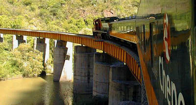
- The Most Dramatic Train Ride
- First Class Train
- Train Riding Tips
- Baja Ferries


Three ways to travel to Creel:
- By Plane
- By Car
- By Bus or Train
For now, all means to get to Creel have to go by way of the State Capitol of Chihuahua City unless you come up from Los Mochis via Baja or come south from Nogales. You can also fly in to Chuhuahua City International Airport. Once in Chihuahua by any means, you can drive to Creel, take a bus or train. The Chihuahua al Pacifico railroad, the Noroeste Bus Lines and the Estrella Blanca Bus Lines all offer good service to and from Creel daily. In the future, the Creel International Airport will eventually be completed, thus offering a quicker route to Creel.
If you're driving to Creel, the Gran Vision Highway is fully paved and it's in good condition from Chihuahua City to Creel. It is only a 3-1/2 to 4 hour drive.
- Chihuahua International Airport (Code: CUU): Located
on Blvd. Juan Pablo II at Km 14, in the city of Chihuahua.
Airport / Tel. (614) 420 0916 /420 0676.
- Chihuahua Bus Terminal: Located at 4107 Blvd. Juan
Pablo II, Colonia Aeropuerto.
Tel. (614) 420-2286 and (614) 420-5184.
- Chihuahua-Pacifico Train: Departs from Los Mochis,
in Sinaloa, and arrives at the city of Chihuahua. There are two classes:
primera express (a first-class ride that departs at 6:00 a.m) and clase
economica (an economy class train that departs at 7:00 a.m.)
Tels. (614) 439-7212 or for the toll-free number dial 01 (800) 122-4373
If you take the train, We recommend riding from the west (Los Mochis) towards the east (Creel and Chihuahua City). This takes advantage of daylight hours and provides the best views.
The most dramatic train ride...
by Scott & Kathleen Seegers
Past towering peaks and over dizzying gorges, you roll across the backbone of the continent — surrounded by the treasures of Mexico's Sierra Madre.
Standing on the brink of the precipice, we stared down into a rift in the earth's crust — part of a system of gorges so huge that it could swallow four Grand Canyons. Some 3000 feet below, the Urique River, which had carved out the gigantic canyon, seemed a tiny silver thread.
We were 7500 feet up at Divisadero, Mexico, on the Continental Divide. Our train had stopped to give passengers time to see and photograph the cosmic landcape —an infinity of buttes, mesas and many-stepped canyons writhing toward the blue haze of the horizon.
"Great snakes! Now I know why it took a hundred years to build this railroad," said a tall Arizonan at our side. He was one of the 250,000 tourists a year like us, mostly from the United States, who take this journey — the most dramatic train ride in the Western Hemisphere.
It is the spectacular 17-hour, 400 mile trip from Chihuahua — southwest across the fearsome ranges of the Sierra Madre — to Los Mochis, 13 miles from the Sea of Cortez. The line is the Chihuahua-Pacific, opened in 1961.
Along the route, we saw vast upland ranches, temperate-zone orchards and tropical valleys, lakes full of trophy fish, boomtowns new and old, and almost unexplored mountain chains inhabited by Indians of such speed and endurance that they traditionally hunted deer by running them down on foot. And we did all of this in one week, at un-inflated prices!
Fleet of Foot
We are at Creel — a jumping-off place for explorers, hunters, mining prospectors, anthropologists and geologists — where we planned to stop for a few days. For years this was the end of the line. Creel is a fascinating mixture of the cosmopolitan and the primitive.
From our cosy hotel we made half-day hikes into the mountains. We walked noiselessly through cathedral aisles of enormous pines, cliffs towering above us on every side, some chiseled by wind and weather into free-standing columns 100 feet high. Here and there in a cliff we saw natural caves, many with a low stone wall across the entrance, the overhanging roof black with the smoke of generations of cooking fires.
These are the abodes of the Tarahumara Indians. Semi-nomadic, they prefer the solitary existence - one family per cave — to living together in neighborhoods. There are about 50,000 Tarahumaras. The government has decreed that they are the collective owners of some 26,000 square miles of the Tarahumara Range.
Over the Top
We left Creel in the glass-domed sightseeing coach of the passenger train. Ahead lay the wildest, most rugged part of the Tarahumara Range. Mile after mile of ridges and vertiginous abysses rolled past our window. We vaulted through the very sky, it seemed, from one razor-backed pinnacle to the next, on soaring spans of bridges (37 of them) anchored in the rock hundreds of feet below. We plunged into tunnels so frequently that often the locomotive was entering a new one before the rear car had come through the last.
The train labored up to the line's highest point — just over 8000 feet — at Ojitos, where the grim backdrop of the Sierra rose another 5000 feet above us. An hour later, we paused for the splendor of Divisadero.
Standing at that chilly height, surrounded by oaks and pines, we could see — through field glasses— oranges and mangoes growing in the tropics more than half a mile beneath us.
End of The Line
The line spills down the Pacific palisade, 7000 feet, in 94 miles of fantastic loops and serpentines. Much of the descent is along the valley of the Fuerte River, first glimpsed as a raging, rock studded mountain stream.
As we dropped, the valleys grew wider and the river more benign and meandering. Then —as the great mountain loomed purple behind us in the sunset— the track made a beeline across the hot, fertile floodplain.

The plain was covered with broad fields of cotton, wheat, soybeans, safflower, sugar cane —and mile upon mile of marigolds, whose dried blossoms are exported to the United States as a component of chicken feed.
We broke our journey —again— at the little town of El Fuerte and we visited some of the thick-walled, one-story houses, with broad, open inner passages surrounding a spacious central patio.
Many are occupied by descendants of the families that built them centuries ago. Others, have been bought by perceptive "yanquis" and refurbished into handsome winter homes.
The railway's passenger service ends at Los Mochis, a clean, bustling city of 50,000, an hour and a half beyond El Fuerte. From there, we took a bus to the end of the line at Topolobampo on the Sea of Cortez.
Topolobampo is a lovely little fishing port dreaming beside a blue, deep-water bay ringed by mountains.
The closing of the Tarahumara gap has opened to the traveler a primitive world of stark beauty and awesome grandeur almost unchanged since the beginning of time.
'Copper Canyon' is generally used by travelers to define the total canyon system, which covers 25,000 square miles. Six of the major canyons in the system are:
- Urique Canyon: 6136 ft. deep
- Sinforosa Canyon: 5904 ft. deep
- Copper Canyon: 5770 ft. deep
- Tararecua Canyon: 4674 ft. deep
- Batopilas Canyon: 5904 ft. deep
- Oteros Canyon: 3225 ft. deep
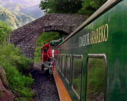
First Class Train
- It leaves everyday from Chihuahua to Los Mochis and from Los Mochis to
Chihuahua at 6:00 a.m.
- It stops only at the tourist destinations of Cuauhtémoc, Creel,
Divisadero (a 15 minute stop to admire the Copper Canyon), Posada Barrancas,
Bahuichivo/Cerocahui, Temoris, El Fuerte and Los Mochis.
- The train features a Dining Cara, a Smoking Bar Car and runs with 2 to 4, 68
passenger-cars. Fully carpeted, a/c and heaters, reclining seats, panoramic windows
and restrooms for men and women.
- The Dining Car opens from 7:30 am to 8:00 pm serving breakfast, lunch and dinner with menu a la carte. No food and beverages are allowed in the passenger cars.
- Bar is open from 10:00 am serving different cocktails and liquors. Cards and
domino games available.
- Both trains operate with an ecological disposal of water. The running water
doesn't flush to the ground, but it is taken to special sewage in Chihuahua or Los
Mochis.
- In every car a helpful Porter travels helping passengers with their luggage and
to assign seats.
- If you have time, it is advisable to stop at least in the stations of Creel and Divisadero to spend a night there.
- From May to the end of June everything is very dry and you might find some
mountain fires.
- Rainy season is between June and late October. It is the best season for
traveling because the landscapes have brighter colors.
- From November through February the temperatures are low and you might have some snow.

Train Riding Tips:
When the trains run on time, it really doesn't matter whether you travel westbound or eastbound, as the most spectacular points (Divisadero, Témoris) are reached in mid-afternoon in either direction. If the westbound train (No. 74) is running late, however, you risk not seeing Témoris – which is scheduled for a 4:30 p.m. arrival going west, 11:11 a.m. going east – in the winter when the sun sets early. Hence if your main objective is the train ride itself (as opposed to stopping over in the Sierra Tarahumara for a few days), the journey is best taken from the western end. Although many people start the trip in Los Mochis, it is just as well begun in El Fuerte since the scenery isn't that spectacular until well east of El Fuerte.
Overall, the best views are seen from the south side of the train, i.e., the left side westbound or the right side eastbound. Since the train windows are rarely kept clean enough for an unobstructed view, passengers often crowd onto the small platforms between cars for a look at the passing scenery.
Wear clothes you don't mind getting dirty if you anticipate standing between cars – the dust and diesel soot outside may not be noticeable at first but they have a definite cumulative effect.
There is no checked baggage for personal items (unless you're dealing with FNM's cargo department), but overhead space is ample for most bags. Seats – arranged four across in pairs – usually recline in first-class cars and there's plenty of leg room. If the train isn't full, you can easily change cars when necessary (e.g., when the a/c or heating system in your car isn't working properly).
Food service is available in the dining cars on the first-class express trains. Drink are served in the bar cars. Snacks are for sale on the second-class trains.
The Chihuahua al Pacífico train suffered several armed robberies in 1993, but by early 1994 state judicial police working with federales and the Mexican army managed to bring all such incidents to a halt. Since then armed guards – either police or soldiers, sometimes uniformed, sometimes in civilian clothes – have accompanied every train trip, both first- and second-class.

Baja Ferries:
 Baja Ferries offers comfortable ferry service between Topolobampo
(near Los Mochis airport) and
La Paz, by way of the Sea of Cortez. Baja Ferries modern and faster ferry replaced the Sematur operated ferries in 2003. This well maintained ferry built in 2002 features a restaurant, a cafeteria area, bar and club salon.

Ferry travel across the gulf is now truly comfortable. Enjoy your time on board in the roomy seating salon or stroll on the deck and take in the wind and sea. To really make your passage first class, invest a little more for a private cabin (sleeps 1 to 4 people) for night time crossings.

Daily Service: West to East (La Paz to Topolobampo)
- Schedule Time: Monday thru Sunday
- Check-in: 13:00h (1PM)
- Departs: 15:00h (3PM)
- Arrival: Topolobampo 21:30h (9:30PM)
Daily Service: East to West (Topolobampo to La Paz)
- Schedule Time: Monday thru Sunday
- Check-in: 21:00h (9PM)
- Departs: 23:00h (11PM)
- Arrival: La Paz 05:30h (5:30AM)
For Reservations call (800) 884-3107 or
visit their
website: Baja Ferries


posted by Margarita Quintero at 3/08/2007 05:00:00 AM Permalink


<< Home